
I did not expect much from the Fox Glacier South Side Walk. It is listed as easy, it takes two hours, and the name makes it sound like a flat stroll to a distant viewpoint. I almost skipped it to save the time for Lake Matheson.
That would have been a mistake.
The track starts in dense West Coast podocarp rainforest and ends at an open moraine with the glacier filling the far end of the valley. The transition between the two environments is sharp enough that it feels almost deliberate. You spend most of the walk in the trees, then the forest opens and there it is – a wall of blue-white ice between two dark ridges, close enough to feel large.
The fox glacier south side walk is free, open year-round, and the trail is well-formed the whole way. If you are driving SH6 through Fox Glacier and you only have time for one thing, this is the one.
What is the Fox Glacier South Side Walk?
The Fox Glacier South Side Walk, officially called the Fox Glacier South Side Walkway/Cycleway, is a 6.4 km return track run by the Department of Conservation. It follows the south bank of the Fox River from a car park on SH6 through to the glacier viewpoint on the valley floor.
The track is rated easy. The surface through the forest is formed gravel, wide and smooth. Near the glacier the path transitions to rocky moraine. There is no real elevation gain – the valley is flat. Walkers should allow around two hours. Cyclists can do it in one.
This walk is separate from the Franz Josef tracks 25 km north. Both glaciers are worth visiting if you have time on the West Coast. I cover Franz Josef in a separate guide – see my Franz Josef Glacier guide.
What to expect on the track
Through the rainforest
The car park is on SH6 approximately 2 km from the Fox Glacier Weheka township. Turn left just before the Fox River bridge if you are coming from Franz Josef. The car park is gravel with no facilities.
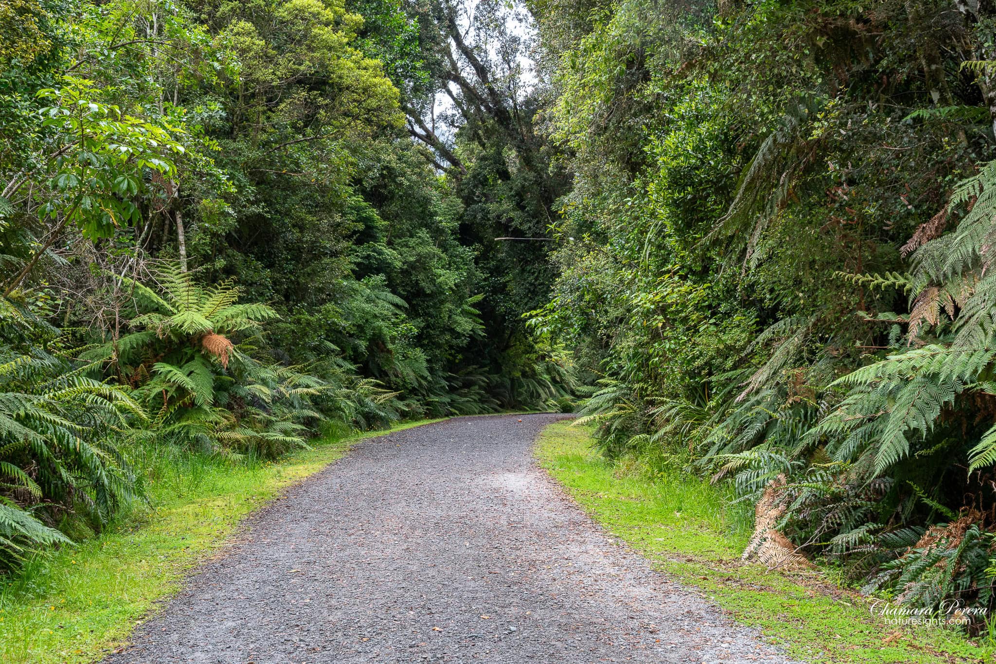
The walk begins on a wide gravel road through dense forest. I was expecting a scrubby approach track, not proper rainforest. But this section is genuinely impressive from the start. Rimu, kahikatea and other podocarp species tower over the road, and tree ferns fill in underneath. The canopy is closed tight.
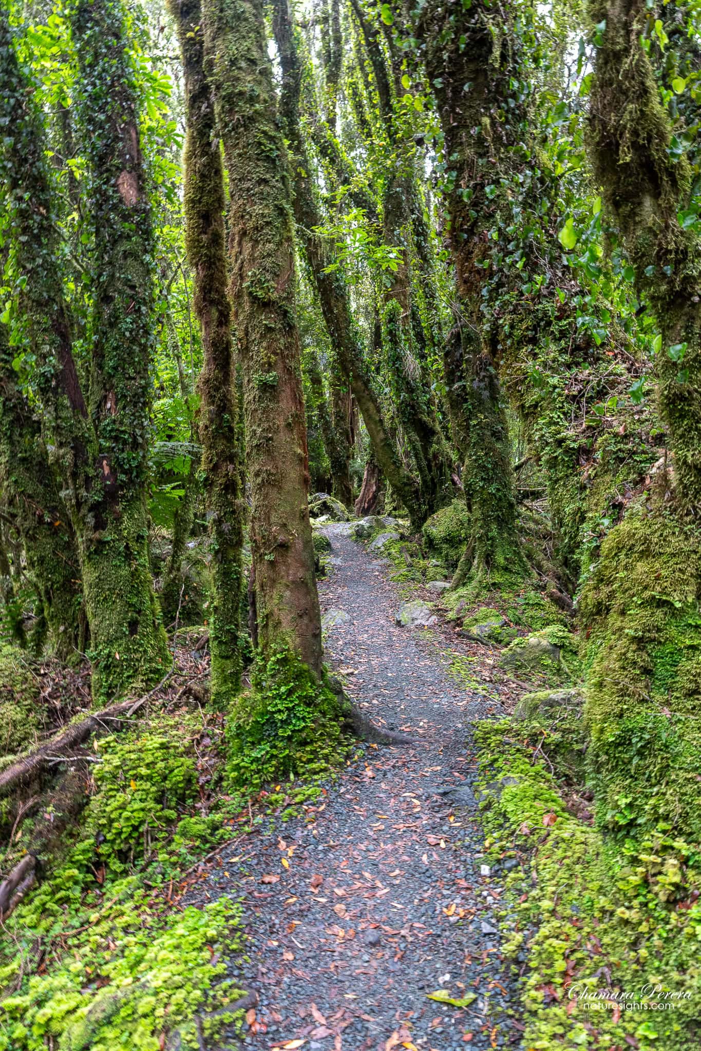
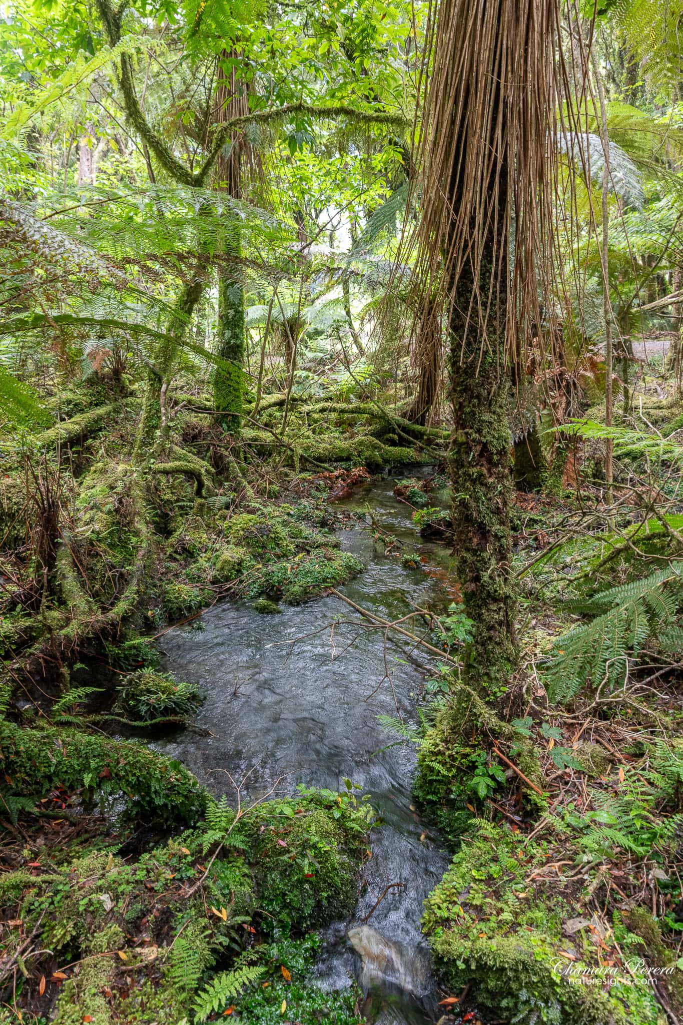
As you go further in, the road narrows to a walking trail. The trees here are old, and many of them are fully covered in moss – the bark, the exposed roots, the fallen logs along the track edge. A few small streams cross through the forest. The water is cold and clear. These crossings are on solid ground, no wet feet, but they slow you down in a good way.
Near the far end of the forest section, I spotted southern rata in flower at the canopy edge. The rata produces masses of red stamens at the tops of the trees – from below it looks like the crown of the tree has been painted red. This happens in summer (December to February) and is worth watching for if you are there at the right time.

The forest is quiet even with other walkers on the track. The density of the vegetation absorbs sound.
At the glacier viewpoint
The forest does not end suddenly. It thins as the valley opens, then you cross onto the moraine – a wide flat of grey boulders and glacial debris. The scale of the valley becomes clear once you are out of the trees. The walls on both sides are steep, the rock scraped bare where the ice sat not long ago. At the far end, the glacier sits between the two ridges.

The day I was there, cloud was sitting on the upper peaks. The lower face of the glacier and the crevassed mid-section came through clearly. Towards the end of my time at the viewpoint, the cloud shifted and briefly revealed the upper glacier and the snowfields above it. West Coast weather does that.

The moraine area is open walking – no designated platform or railing, just the rocky flat. DOC signs mark where you should stop. The glacier is an active environment and the ice calves without warning.

The glacier face is a striking blue-white against the surrounding grey rock. Through a telephoto lens you can see the individual crevasses and the folds in the ice where it moves down the valley. Even on a flat overcast day, the colour separation between ice and rock is strong enough for good images.

Wildlife and nature on the track
The podocarp rainforest along the Fox River is some of the most intact lowland forest left on the West Coast. Trees here reach sizes you do not see in younger or more disturbed stands. The understorey has at least a dozen fern species without looking hard, and the mosses cover everything in the wetter sections.
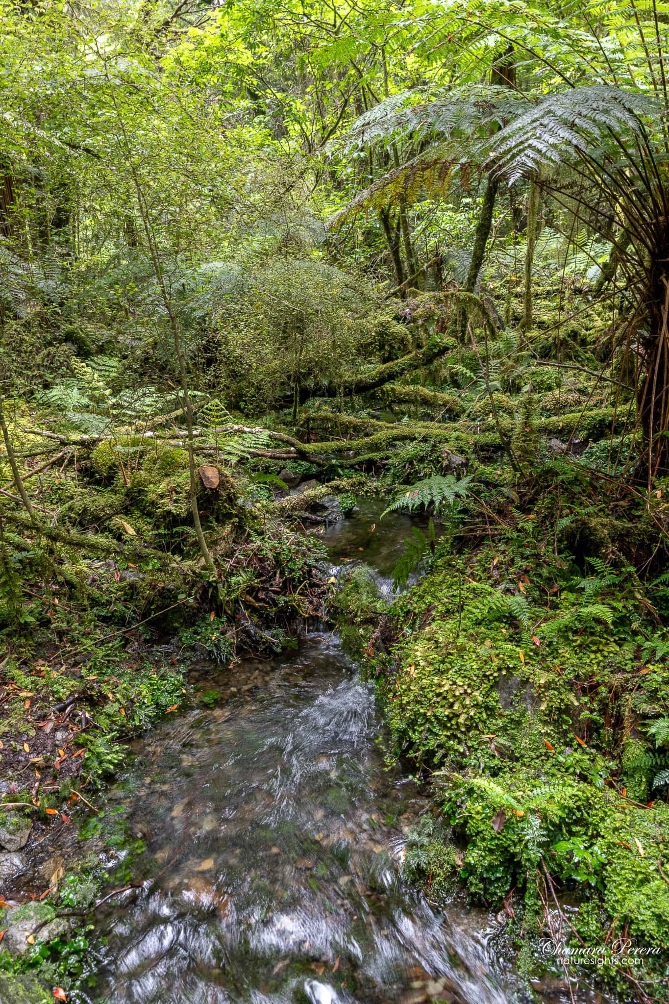
The streams running through the forest are glacier-fed – cold even in summer.
The southern rata is worth a mention again. The flowers are high up and the individual blooms are small, but a tree in full flower is unmistakeable. It is also one of the main reasons tui and bellbird are so active in the area during summer.
Photography tips
Overcast conditions, which are common here, work well for the forest sections. Flat light means no harsh shadows in the understorey and the greens of the ferns and mosses come through saturated and rich. I shot the forest in these conditions and was happy with what I got.
For the glacier views, some cloud is fine. A few clouds moving across the upper peaks add drama, and a brief clearance can reveal the full height of the ice. Total coverage flattens the shot and removes the context of the peaks above.
The best glacier compositions from the moraine use the valley walls as natural framing. Position yourself so the two ridges converge towards the ice face. The rocks in the foreground give the shot a sense of scale and distance.
For the forest, slow down and work the smaller compositions. The stream crossings, the way the mossy path curves ahead, the patterns on an old fallen log. A wide angle captures the full tunnel effect on the narrower sections. At the viewpoint, switch to a longer lens if you have one – the glacier face has real detail at this distance.
Morning is better than afternoon. Cloud tends to build through the day on the West Coast, and the light comes into the valley from the east. Early starts also mean fewer people on the track.
How to get there
The car park is on SH6, approximately 2 km south of Fox Glacier Weheka township. Coming from Franz Josef: cross the Fox River bridge, and the car park turn-off is on your left immediately after the bridge. Coming from the south, it is on your right just before the bridge.
The car park is gravel, free, and open 24 hours.
Fox Glacier township is 25 km south of Franz Josef on SH6. From Greymouth, allow around 2.5 hours. From Queenstown via the Haast Pass, the drive is around four hours.
There is no public transport to the car park. You need your own vehicle.
Best time to visit
The track is walkable any time of year. The West Coast is wet regardless – annual rainfall here is among the highest in New Zealand – so a waterproof layer is worth packing whatever the forecast says.
Summer (December to March) gives you the best chance of clear skies, and the rata flowers during this period. Days are long, which gives you flexibility for early morning light. The track is also at its busiest.
Autumn (March to May) is quieter and often has softer light. The forest does not change colour the way temperate deciduous forests do, but the conditions are generally pleasant.
Winter can bring snow to the upper glacier and makes for dramatic shots, but low cloud can sit in the valley for days. If you visit in winter, be prepared to wait or accept partial views of the glacier.
Spring (September to November) brings variable weather. The snowline on the peaks is often still low, which adds to the backdrop if the cloud clears.
Morning is almost always better than afternoon for glacier views. Cloud tends to build through the day.
Where to stay
The Fox Glacier Weheka township is small but has enough accommodation for an overnight stop. Staying at least one night makes sense – you can do the south side walk in the morning and spend the afternoon at Lake Matheson, which is only 3 km from the township. The lake reflection of Aoraki/Mount Cook and Mount Tasman is one of the best views in New Zealand on the right morning. I wrote about it in my Lake Matheson guide.
I stayed at Fox Glacier Lodge during my visit – comfortable rooms right in the village, easy walking distance to the restaurants and the start of the Lake Matheson road. Book ahead in summer – the village is small and accommodation fills up fast.
Practical tips
The track is 6.4 km return and takes around two hours at a comfortable walking pace, more if you are stopping for photos.
It is rated easy. The formed gravel surface through the forest is fine for trail shoes. The moraine section near the viewpoint is uneven rock but there is no scrambling involved.
The track is free with no entry fee. Open year-round, 24 hours.
There are no toilets at the car park. The Fox Glacier township has facilities about 2 km away.
You can also cycle the track. Mountain bikes or hybrid bikes handle the gravel section without trouble.
DOC occasionally closes the track after heavy rain or when the glacier environment is unstable. Check the DOC website before you go.
Frequently asked questions
How long is the Fox Glacier South Side Walk?
The Fox Glacier South Side Walk is 6.4 km return. Most walkers finish in around two hours at a relaxed pace. On a bike, the same distance takes about an hour return.
Is the Fox Glacier South Side Walk worth doing?
Yes. It gives you two different environments in one short trip – proper West Coast rainforest and an open glacier valley – and the viewpoint makes the walk feel purposeful rather than just a forest stroll. It has a 4.6 out of 5 rating on AllTrails from nearly 2,000 reviews, which reflects what most visitors find: it is short, easy and the payoff at the end is real.
Where do you park for the Fox Glacier South Side Walk?
The car park is on SH6 approximately 2 km south of Fox Glacier Weheka township. Turn left immediately after crossing the Fox River bridge if you are coming from Franz Josef. The car park is gravel and free.
Can you see the glacier clearly from the viewpoint?
Yes, assuming the cloud is not sitting too low. The walk ends at an open moraine with a direct view of the Fox Glacier face and the valley it flows through. The lower face and crevassed mid-section are usually visible even on overcast days. How much of the upper glacier you see depends on the cloud level – partial cover is common on the West Coast.
Is this walk suitable for children?
Yes. The track is easy and the surface is formed gravel for most of its length. The moraine section near the viewpoint is rocky but flat. Children who can walk 6 km on flat ground will be fine. Follow the DOC signage at the viewpoint about safe stopping distances from the glacier face.
Final word
I almost skipped this walk. I had driven a long stretch of the West Coast highway that day and was tired, and two hours felt like a lot. I did it anyway, mostly out of obligation.
Worth every step of it.
If you are doing the West Coast, stay overnight at Fox Glacier rather than pushing on. Do the south side walk in the morning and Lake Matheson in the afternoon. Between the two, you get a very full picture of why this part of the South Island gets the reputation it does.
For more New Zealand destinations, visit my New Zealand travel guide.