
I pulled into the Knights Point Lookout car park and the view was already better than anything I’d seen that morning. Rocky stacks sat out in the Tasman Sea, the forested cliffs dropped straight to a curved beach below, and the cloud was doing something dramatic above the horizon. It lasted maybe ten minutes before the drizzle started again. Those ten minutes were enough.
Knights Point is about halfway between Fox Glacier and Haast, roughly 50km south of the glacier on State Highway 6. I had a full day of driving ahead – south to Haast, then east through the Haast Pass New Zealand section, and eventually all the way down to Te Anau. What I didn’t expect was how much the pass itself would deliver. Waterfall after waterfall, a turquoise river running alongside the road for most of the way, and mountain views that kept changing right up until I parked the car for the night.
Knights Point Lookout

The car park is right off SH6, signposted from the road, with a short path up to the lookout platform. The views go straight west over the Tasman Sea. On a clear day you’d see the full sweep of the coast – on the overcast day I was there, the light was flat but the scene still worked.
There’s a stone marker at Knights Point commemorating the opening of the road in 1965. Before the road was completed, the West Coast was genuinely isolated from the rest of the South Island in this direction. The marker is easy to miss if you’re focused on the sea view.
Stop time: 10 to 15 minutes.
The drive from Fox Glacier to Haast

The coastal stretch of SH6 between Fox Glacier and Haast is 121km and takes about 1 hour 20 minutes without stops. It’s mostly two-lane road through rainforest, with gaps where the Tasman Sea opens to the west. The road is well sealed and not technically difficult, but the scenery changes often enough to keep you paying attention.
The drive is genuinely good even when the weather isn’t. Low cloud sitting on the forest-covered hills, wet road, mist in the trees – that atmosphere is part of what the West Coast does.
By the time I reached Haast township I’d been driving about 90 minutes from Fox Glacier. The township is small – a petrol station, a shop, a pub and a few motels. Fill the tank here. The next reliable fuel stop is Makarora, 90km east through the pass, and there’s nothing in between.
Roaring Billy Falls

The Roaring Billy Falls car park is about 20km east of Haast on the Haast Pass road. There’s a DOC sign, a picnic table, and a short track down to the Haast River flats.
The walk is 15 to 20 minutes each way, but what makes it different from a standard waterfall track is how you get to the view. You cross an open river beach – a wide, flat expanse of white cobblestones – to reach a spot directly across from the falls. The Haast River runs between you and the base of the falls, fast and glacially cold. You don’t reach the falls. You stand on the cobbles and look across at them.

I stood on those river stones for a while. The water was grey-green-blue – the colour that New Zealand’s glacial rivers do better than anywhere else I’ve been. The falls drop from the forested hillside in a series of cascades, not the biggest on the route but set against a backdrop that’s hard to improve on: river, cobble beach, dense rainforest, cloud-covered peaks behind.

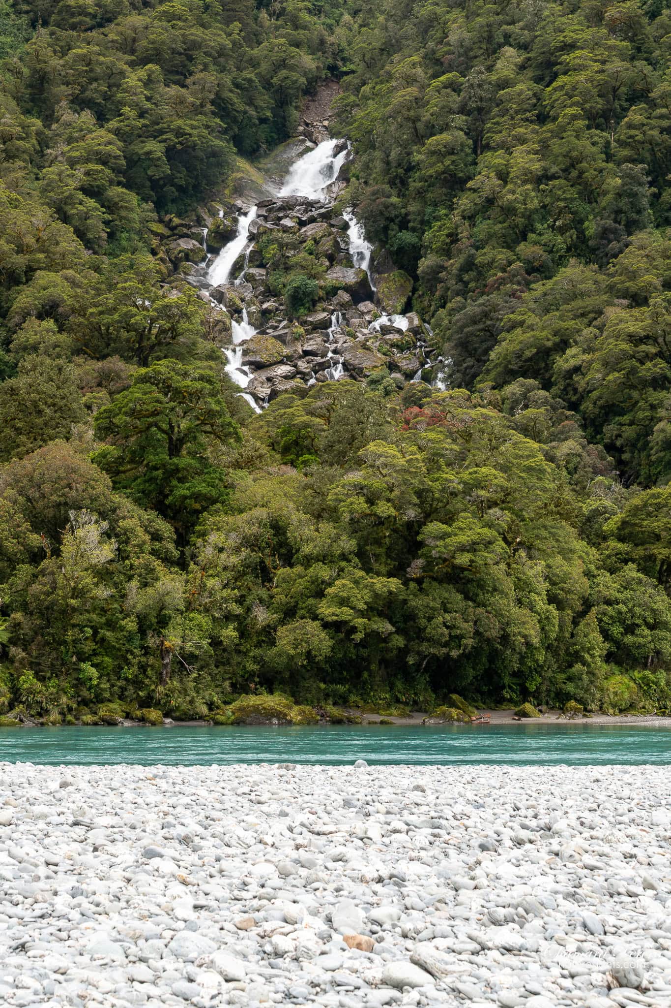
Sandfly repellent is essential here – and even with spray it only does so much. I had repellent with me and still had a hard time. The moment you stop moving they are on you. Standing still long enough to frame a photo means getting bitten. Apply before the walk and reapply at the river beach. Bring the strongest spray you can find, not the light stuff.
Stop time: 35 to 45 minutes including the walk.
Thunder Creek Falls
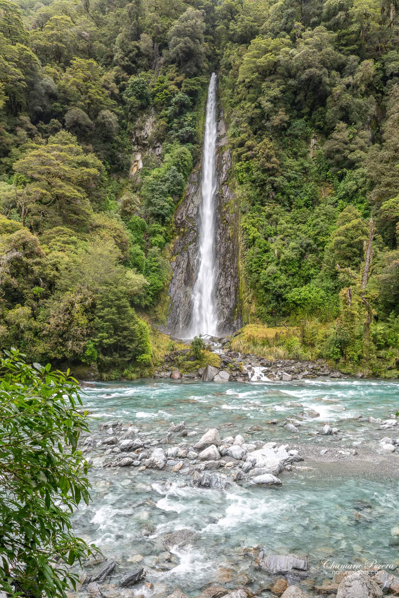
Thunder Creek Falls is the stop I kept seeing in other people’s photos before the trip, and it’s easy to understand why. A single jet of water drops about 28 metres from a cliff face on the right side of the road, falling straight into the Haast River at the edge of the car park. You can see it from the road without stopping.
Stop anyway. There’s a short track – 5 minutes each way – that takes you to a viewpoint directly opposite the falls. That’s where the real angle is: the full drop, the turquoise river in the foreground, the forest closing in on both sides.
Up close, the roar is louder than the scale suggests from the car park. The water hits the river hard and the sound carries up the canyon. A five-minute walk is a small trade for that view.
Stop time: 15 to 20 minutes.
Gates of Haast
A couple of kilometres past Thunder Creek, the road crosses the Haast River at the Gates of Haast gorge. Pull over on the bridge and look upstream – the river pushes through a narrow rock gap in a surge of white water. It’s violent in a way that’s hard to anticipate until you’re standing over it.
Five minutes is enough here. It’s more a dramatic moment in the drive than a dedicated stop.
Fantail Falls
Fantail Falls is about 87km from Wanaka on SH-6, roughly an hour’s drive. Coming from Haast, it’s one of the last stops before the pass summit. The sign is on the right, the car park is right there, and there are no facilities – just the track and the falls.
The walk is 10 minutes return and flat. It brings you out onto the Haast River gravel bed with the falls directly across the water. You don’t need to cross – they’re fully visible from here. It’s a fan-shaped drop of about 23 metres, the water spreading wide across the rock face as it falls – a broad sheet covering most of the cliff, not a single jet. After rain it fills out considerably.
You can cross the river with care and reach the base if you want. I stayed on the lookout side. The view is good from the gravel bed and the crossing looked cold.
Stop time: 15 to 20 minutes.
Makarora Valley and the pass summit
After the gorge, the road climbs through beech forest and then opens into the Makarora Valley. This is where the character of the whole drive shifts – from rainforest and waterfalls to open valley and mountain pasture.

The Haast Pass summit sits at 563 metres. There’s a small sign off the road marking the saddle. It’s not dramatic at the top – just a flat spot in the trees – but the descent east into the Makarora Valley is worth paying attention to. The valley opens up fast and wide.
There’s a DOC campsite at Makarora and a small store that sells fuel and basic food. I stopped for coffee and a meat pie. The valley itself is worth slowing down for – the Makarora River running through the flats, beech-covered hills on both sides, the whole thing looking like it belongs in a different country from the rainforest coast two hours back.
Stop time: 15 to 20 minutes at Makarora.
Lake Hawea
After Makarora, SH6 runs along the shore of Lake Hawea. The lake is about 35km long and the road hugs the western shore for most of that distance. The water is grey-blue, the surrounding hills are dry and brown compared to the Haast Pass side, and the mountain backdrop at the far end grows as you drive south.

I pulled over at two or three places along this section. The best view was where the road curved south and you could look straight down the length of the lake to the mountains behind. Late afternoon light would be better here than the overcast mid-afternoon I had, but even in flat light the scale of the place comes through.

Stop time: 15 minutes across a couple of pull-offs.
The final stretch to Te Anau
From Lake Hawea the route continues through Wanaka and then south. Wanaka is the natural stop for lunch or a proper break – it has cafes, a supermarket and a good lakefront. From Wanaka, the drive south through Cromwell and Lumsden to Te Anau takes about 3 hours.
The approach to Te Anau from the north comes down through farmland, with the Fiordland peaks visible to the west as you get closer. The first time you see those jagged, cloud-wrapped ridgelines through the windscreen, you know the drive is nearly done and something else is about to start.

Total drive time Fox Glacier to Te Anau: 6 to 7 hours of actual driving, plus 2 to 3 hours for stops. Start early.
Photography tips
At Thunder Creek Falls, arrive before noon if you can. The falls face roughly north-east and the morning light is better. Shoot from the viewing platform opposite, wide enough to get the full drop and the river in frame. A polarising filter makes a clear difference on the river colour.
Fantail Falls is best shot from the gravel bed. Shoot wide enough to get the full spread across the rock face – that’s what makes it different from the other falls on this route. The river in the foreground helps. Overcast light keeps the rock face evenly lit, which is what you want here.
Roaring Billy Falls is harder to shoot than it looks. You’re working across open water with the falls on the far side. Morning light works better here – the hillside behind the falls faces east.
Knights Point faces west, which means afternoon is better for the sea. If you’re driving south from Fox Glacier you’ll arrive in the morning, but overcast sky removes harsh shadows and I think it helped on the day I was there.
Lake Hawea is best late afternoon. The dry eastern hills catch warm colour when the sun drops west, and you’re shooting toward the mountain end of the lake from the western shore.
Gear I used: Nikon D850 with Tamron 24-70mm f/2.8 G2. A tripod would have helped at Thunder Creek Falls for a long-exposure shot, but hand-held at 1/250s worked fine in the overcast conditions.
How to get there
The route runs along State Highway 6 for the entire journey.
From Fox Glacier, drive south to Haast – 121km, about 1 hour 20 minutes. At Haast, continue east on SH6 through the Haast Pass – 145km to Wanaka, about 2 hours without stops. From Wanaka, drive south through Cromwell and Lumsden to Te Anau – about 3 hours.
The road is fully sealed. The Haast Pass section can close after heavy rain or slips – check the NZTA journey planner before you go, especially in winter. No four-wheel drive needed. A standard rental car handles the entire route.
Best time to visit
I did this drive in late December on an overcast day and the stops all delivered. The waterfalls were running well – summer rain on the West Coast is normal and the falls are better for it.
Spring (October to November) and early summer (December) tend to bring higher water flow in the falls, along with more frequent rain. Autumn (March to May) gives more settled weather and the beech forest on the Haast Pass starts turning colour in April and May.
Winter (June to August) is possible but the pass can be affected by snow and ice near the summit. Check road conditions before going.
The waterfalls along the pass run all year. They don’t dry up in summer – they’re fed from high snowfields and the West Coast’s near-constant rainfall.
Where to stay
Te Anau Motel & Apartments
I stayed at the Te Anau Motel & Apartments in Te Anau. It’s on the main street, a short walk from the lakefront. I had a self-contained unit with a kitchen, which was useful after a long day on the road. The rooms are comfortable, parking is on-site and the location is as central as it gets in a town this size.
Te Anau is the right base if you’re continuing to Milford Sound or Doubtful Sound the next day. Milford is 120km and takes about 2 hours. Doubtful Sound goes via Lake Manapouri, 20 minutes south of town.
Practical tips
- Fuel up in Haast before the pass. Makarora has fuel but it’s a small operation with limited hours and higher prices.
- Car parks at all waterfall stops are free. There’s no entry fee for any of the DOC areas along the Haast Pass.
- Sandfly repellent is essential at Roaring Billy Falls – and anywhere on the West Coast. Even with strong spray you will still get bitten the moment you stop moving. Apply before the walk and keep moving at the river. Bring the strongest spray you can find.
- The walk to Roaring Billy crosses an open river beach. After heavy rain, parts of the river flats can be flooded. Check conditions at the DOC sign before heading across.
- Fantail Falls has no facilities – nearest toilets are at Pleasant Flat Campsite, 10km back toward Haast.
- Thunder Creek Falls can be seen from the road. Stop anyway – the walk is 10 minutes return and the close-up view is worth it.
- Mobile coverage is patchy through the Haast Pass and the drive south to Te Anau. Download maps offline before you leave Haast.
- The whole Fox Glacier to Te Anau drive takes a full day with stops. Don’t add another long drive to the end of it.
FAQs
Is the Haast Pass drive worth doing?
Yes. The combination of the coastal section between Fox Glacier and Haast, the waterfall stops through the pass and the Makarora Valley makes this one of the best driving days on the South Island. Most people drive it as a day trip between Wanaka and the glaciers – if you’re doing the full route through to Te Anau, you get everything in one direction without backtracking.
How long does it take to drive the Haast Pass from Haast to Wanaka?
About 145km and roughly 2 hours without stops. With stops at Roaring Billy Falls, Thunder Creek Falls, Gates of Haast, Fantail Falls and Makarora, allow 4 to 5 hours.
How long does it take to drive from Fox Glacier to Haast?
Fox Glacier to Haast is 121km and takes about 1 hour 20 minutes. The coastal road is two-lane, sealed and passes through rainforest with the Tasman Sea to the west.
Can you walk to Thunder Creek Falls?
There’s a short track (5 minutes each way) from the car park to a viewpoint directly opposite the falls. You can also see the falls from the road. There’s no track to the actual base – the water drops directly into the Haast River.
What is the road like through the Haast Pass?
SH6 through the pass is fully sealed, two-lane and in good condition. No difficult sections – a standard rental car handles it without any issue. The summit is at 563 metres. Check NZTA for any closures in winter or after heavy rain.
I’d still do this whole drive as a single day if I were starting the South Island from scratch. Coast, rainforest, waterfalls, alpine pass, high-country valley, mountain lake – and it builds in the right order. By the time I reached Te Anau that evening and saw the first Fiordland peaks through the windscreen, it felt like the day had gone exactly as a day should.
Take the whole day. Don’t skip the stops.