Tasman Valley Road turns off SH80 about 3 kilometres before Mount Cook Village. The sign is small and easy to miss. Most people heading to the Hooker Valley Track drive straight past it without a second look.
The Tasman Glacier View Track is a 1.5km return walk inside Aoraki/Mount Cook National Park that climbs the old moraine wall above Tasman Lake. From the top, you look directly down at New Zealand’s longest glacier – a wide lake covered in floating icebergs, a blue ice face at the far end. It takes about 30 to 45 minutes to reach the viewpoint, and it is one of the better short walks I’ve done at Mount Cook.
I went straight there after finishing the Hooker Valley Track. The Tasman Valley is completely separate – different road, different carpark, different view. Most people visiting Mount Cook skip it entirely.
What is the Tasman Glacier View Track?
The Tasman Glacier View Track is a short, steep climb up the lateral moraine of the Tasman Glacier in Aoraki/Mount Cook National Park. The track starts at the Blue Lakes carpark at the end of Tasman Valley Road – about 7km from the SH80 turnoff and roughly a 15-minute drive from Mount Cook Village.
The path climbs approximately 300 rock steps with an elevation gain of 86 metres. At the top you’re standing on the crest of the moraine wall looking directly down at Tasman Lake. The Tasman Glacier flows into the far end of the lake, and when ice has recently calved off the face, icebergs are floating on the water below you.
The walk is officially classed as easy to moderate. The steps are the only real challenge – the track is short, but it is all uphill with no flat sections until you reach the crest. Most people reach the viewpoint in 20 to 30 minutes.
There is also a Blue Lakes detour branching off partway up. More on that below.
Getting to the carpark
The turnoff is Tasman Valley Road, signposted off SH80 about 3km before Mount Cook Village. If you’re coming from Tekapo you reach it before the village. The road runs about 7km through flat tussock valley to the carpark at the end.
There is a shelter at the carpark with toilets. No entry fee and no booking required.
If you’re based in Lake Tekapo, the drive is about 1.5 hours. The mountains build gradually in the windscreen as you come up SH80, then fill it completely on the final flat stretch toward the village.

The walk up
The track starts flat from the carpark, passes the shelter, then hits the steps. That’s most of it – up. The rock steps are well cut and consistent, and while there are roughly 300 of them, you go at your own pace. The elevation gain is 86 metres over a short horizontal distance, so it feels steeper than that number suggests.
Looking back as you climb, the flat Tasman Valley opens below you – the river threading across the gravel plain toward the road, the valley walls on both sides. There is no shade on the track. On a warm day, bring more water than you think you need.

On my visit, cloud was sitting low over the upper mountains. The valley below was clear but the peaks were in and out. I reached the top and the lake was completely open.
The Blue Lakes detour
About halfway up, a signed side track branches left to the Blue Lakes. These are small glacial tarns sitting in a hollow just below the moraine crest, fed by glacial melt.
The lakes are small glacial tarns in a hollow just below the moraine crest. The colour is the same pale blue-green as every glacially-fed lake in this part of New Zealand – glacial flour suspended in the melt water. The detour adds about 10 minutes each way.
The viewpoint
The viewpoint sits on the crest of the moraine wall. There is no railing or platform – you walk out onto the wide rocky crest and the lake opens up below you.


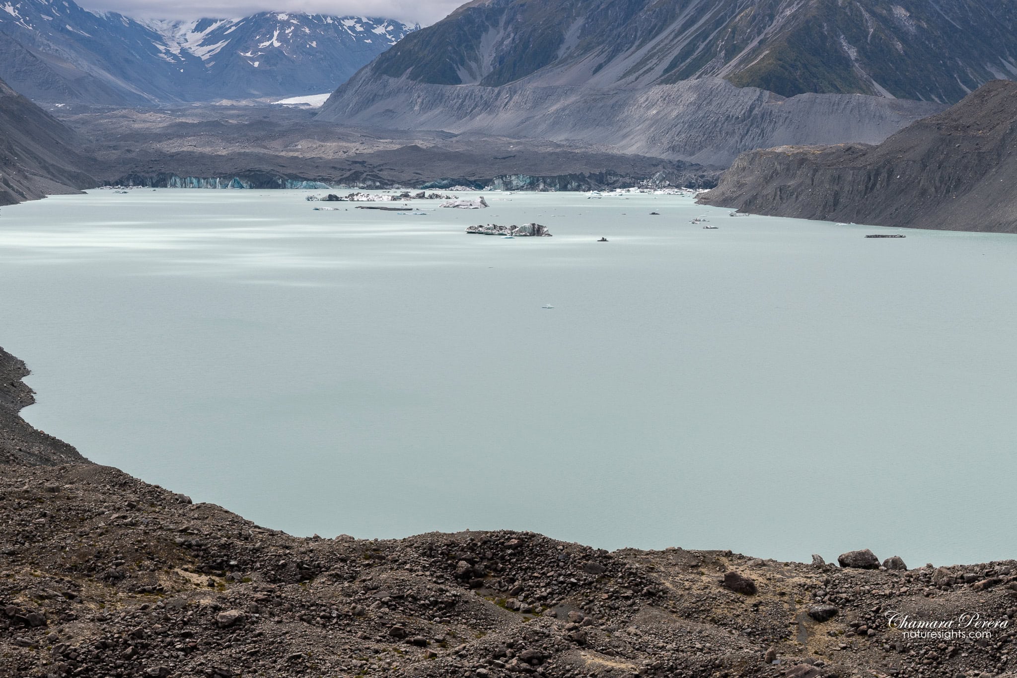
Tasman Lake is large. Not immediately obvious from a map, but standing on the moraine looking down, you can see the full stretch of it running toward the glacier face. The water is pale turquoise – the same glacial flour colouring as Mueller Lake and Hooker Lake on the other side of the valley.
When I was there, icebergs were floating at several points across the lake. Some were house-sized chunks sitting white and irregular on the flat water. The glacier terminal face at the far end was visible as a band of blue ice cutting across the grey moraine walls.


While I was watching, a small orange zodiac boat made its way across the lake toward one of the larger icebergs. The Glacier Explorers tour operates on Tasman Lake, and from the viewpoint you look almost straight down at it. The boat pulled alongside the ice – maybe four metres above the waterline – and sat there. The boat was tiny next to it. That’s the moment the scale made sense.


I stayed longer than I planned. The moraine crest is a strange place to be. Bare rubble on one side, the lake several hundred metres below on the other. The light kept shifting as cloud moved across the upper peaks. I had no reason to rush back down.
Photography tips
I used a Nikon D850 with a Tamron 24-70mm f/2.8 throughout.

The viewpoint faces roughly north, looking up-valley toward the glacier. Morning light comes in from the right and gives the moraine walls and mountain faces some texture. Midday is flat. Evening light can work well too – the low angle catches the ice in good colour.
For the lake shots, the wide end works well for the full panorama. The 70mm end of my zoom compressed the distance to the glacier terminal face and brought the blue ice closer in the frame.
Overcast is fine here. The turquoise of the lake comes through without direct sun, and the cloud adds depth to the mountain shots behind the glacier. A clear day is better for seeing the full extent of the ice, but flat cloud is not a reason to skip the walk.

The Glacier Explorers tours run during the day. I watched the zodiacs from the moraine in the afternoon – portrait format works well for these shots, getting moraine foreground, pale water, icebergs and mountain walls all in one frame.
How to get there
The Tasman Glacier View Track starts from the Blue Lakes carpark at the end of Tasman Valley Road.
- From Mount Cook Village: Take SH80 back toward Tekapo for 3km and turn left onto Tasman Valley Road. Drive 7km to the end of the road.
- From Lake Tekapo: 1.5 hours via SH8 and SH80. Turn right onto Tasman Valley Road before reaching the village.
- From Christchurch: approximately 3.5 hours via SH1 and SH8.
- From Queenstown: approximately 2.5 to 3 hours via SH8 through Twizel.

Fill up with fuel before Twizel. There is no petrol at Mount Cook Village. The Tasman Valley Road is sealed and fine for any vehicle.
Best time to visit
Summer (December to February) is peak season. The carpark fills by mid-morning. An early start – before 8am – matters here, for the light and for the parking.
Shoulder season (October-November and March-April) is quieter with decent weather. Spring often brings more snow on the upper peaks, which photographs well from the moraine.
Winter (June to August) is cold and the days are short. The track stays open year-round, but the rock steps can be icy. A clear winter morning here is genuinely good – the ice on the lake is more extensive and the light is low and sharp.
The Glacier Explorers boat tours operate from around October to late April. If you want to watch the zodiacs from the moraine viewpoint, visit during that window.
Check MetService specifically for Mount Cook before going. Weather in the park changes fast and does not follow conditions at Tekapo or Twizel. Clear skies an hour away do not mean clear skies at the glacier.
Where to stay
I stayed at Neptune Holiday House in Lake Tekapo and drove up in the evening – about 1.5 hours each way. Lake Tekapo has more options at lower prices than Mount Cook Village and makes a good base for both the Tasman Glacier and the Hooker Valley.
Mount Cook Village has:
- Aoraki/Mount Cook Alpine Lodge
- The Hermitage Hotel – expensive, right at the village
- White Horse Hill Campground – basic DOC-managed camping near the Hooker Valley trailhead
If you want to stay in the village, book well ahead in summer. It fills fast.
Practical tips
- Distance: 1.5km return to the viewpoint
- Time: Allow 45 minutes to 1 hour return (add 20 minutes if you do the Blue Lakes detour)
- Difficulty: Easy to moderate – short but steep, all on rock steps
- Elevation gain: 86 metres
- Cost: Free
- Carpark: Blue Lakes carpark, end of Tasman Valley Road
- Facilities: Toilets at the carpark shelter
- Track surface: Rock steps throughout
- No shade on the track – bring sunscreen and more water than you expect to need
- Dogs: Not permitted anywhere in Aoraki/Mount Cook National Park
- Start time: Early in summer to beat the crowds
Frequently asked questions
How long does the Tasman Glacier View Track take?
The viewpoint is about 20 to 30 minutes from the carpark. Most people do the full return in 45 minutes to 1 hour. Add the Blue Lakes detour and allow up to 1.5 hours total.
How do I get to the Tasman Glacier View Track?
Turn off SH80 onto Tasman Valley Road about 3km before Mount Cook Village, coming from the Tekapo direction. Drive 7km to the carpark at the end of the road. The track starts near the shelter at the carpark.
Is the Tasman Glacier View Track worth doing?
Yes. The viewpoint is one of the better views in the Mount Cook area – you’re looking directly down at a large glacial lake with icebergs floating in it, and the blue ice terminal face of the glacier at the far end. You can do it alongside the Hooker Valley Track on the same day.
Can you see Aoraki/Mount Cook from the Tasman Glacier View Track?
On a clear day, yes – the mountain is visible from the upper section and from the viewpoint. It rises to the left when you’re facing the lake. In overcast conditions the summit is usually in cloud, but the lower mountain walls and the glacier face are clear regardless.
Do you need to book or pay for the Tasman Glacier View Track?
No booking and no entry fee. The carpark is first-come, first-served. In summer, arrive before 9am to be sure of a space.
Final thoughts
The Tasman Valley turnoff is easy to miss, the walk is short, and it’s not the one most Mount Cook guides lead with. You could skip it. Most people do.
From the moraine crest you’re looking down at an active glacier from above – icebergs on turquoise water, a blue ice wall at the far end, mountain walls on three sides. The Hooker Valley Track is more famous and deserves to be. But the Tasman Glacier view is different, and you can do both walks in one morning.
For the full guide to the Hooker Valley Track, including the icebergs at Hooker Lake and the swing bridges, see that post. For more South Island walks and drives, the New Zealand travel page has everything I’ve covered.
