The alarm went off at 2:30am. My wife and I looked at each other, both wondering if this was a terrible idea. The kids were still half-asleep in the back of the car as we drove out of Albert Town toward the Roy’s Peak trailhead in the dark. We wanted the sunrise. We got something different – and honestly, I am not sure it mattered.
The Roy’s Peak hike in Wanaka is one of the most talked-about day hikes in New Zealand. The viewpoint looks straight down over Lake Wanaka, across to Mount Aspiring and a full wall of Southern Alps peaks. It is a serious climb. What nobody warns you about is how different the experience is when you do it with family, in the dark.

What Is the Roy’s Peak Track?
Roy’s Peak Track is a 16km return hike starting from a car park on Wanaka-Mount Aspiring Road, about 6km from Wanaka township. The track climbs roughly 1,300m from lake level to a summit at 1,578m. It is graded hard – steep throughout, wide, mostly compacted dirt with no technical sections, no ladders, no chains.
The first section passes through private farmland before you reach the open tussock ridgeline. You pay a small access fee at an honesty box near the start of the private land section – just bring a few coins or a small note.
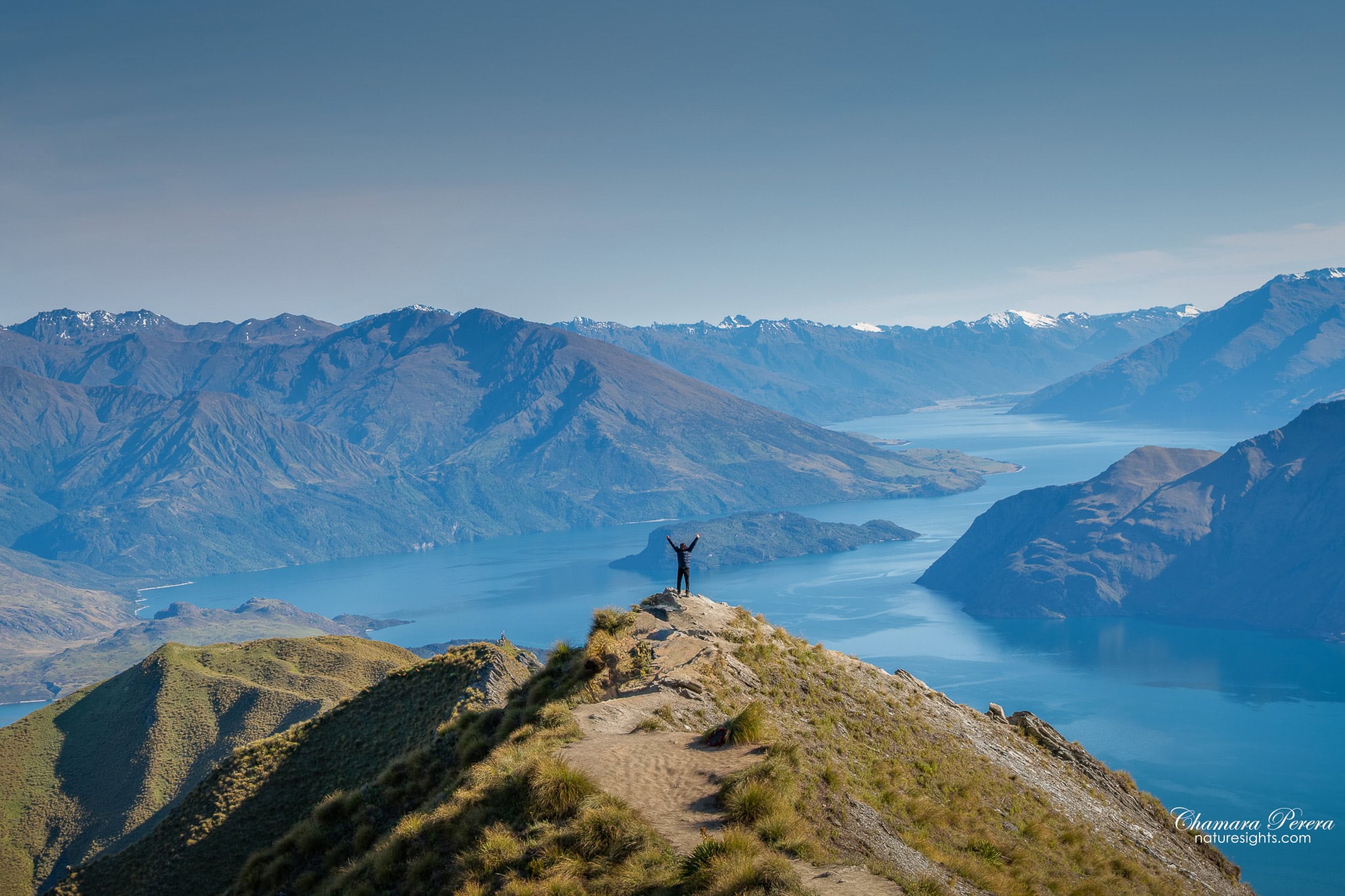
The official destination is the summit at 1,578m, but most people stop at the main viewpoint spur around 1,400m. That is where the iconic photo is taken – a narrow ridge with Lake Wanaka spreading far below. We stopped here. We did not push to the true summit.
The 2:30am Start
We drove from Wanaka Riverside Retreat in Albert Town. The car park is about 10km from Albert Town, and we arrived just before 3am. There were already cars there.
By the time we started walking it was pitch dark. Head torches on, the kids moving quietly. Wanaka’s lights were reflecting in the lake far below. I still think about that first half-hour.
The plan was to reach the viewpoint before sunrise. We did not make it.

With a family, the pace is different. We stopped often – more than I expected. The elevation gain on Roy’s Peak catches up with you quickly. The track does not level off or give you breathing room. It keeps climbing from the car park until you reach the ridge. There is no flat section in the middle to recover. We sat on rocks, ate snacks, drank water, kept going. The kids were good about it. But this is not a hike where you want to rush anyone.


Seeing the Sunrise from Below
Further into the climb, as the sky started to light up behind the mountains, I turned and looked back toward the summit. The top of Roy’s Peak was lit in full orange-gold sunrise light while we were still in shadow below.
A long line of climbers stood silhouetted on the summit ridge, caught in that first burst of morning light. I photographed them from below with the Tamron 24-70mm on my Nikon D850. The contrast between the glowing orange peak and the dark hillside below made for one of the better shots of the day. I would not have got it from the top.


The Sheep and the Honesty Box
I did not expect sheep on the way up. The lower section passes through private farmland, and sheep were grazing on both sides of the trail in the dark. We walked through quietly and they mostly ignored us.
The honesty box is a small wooden box at the gate where you pass from the public track onto private land. Leave a few dollars per person as you go through. It is not enforced, but this is someone’s working farm and the access is a privilege. Do not skip it.
The Trail in Detail
Wide, compacted dirt and gravel. No steps, no ropes, no scrambling. The steepness is the whole challenge. The track winds in long switchbacks up open hillside with almost no shade. On a clear day the sun is on you the entire climb.
From the car park to the main viewpoint is roughly 7km one way. Add about 1km each way if you push to the true summit. Fit walkers will reach the viewpoint in 2.5 to 3 hours. We took longer with rest stops.


The descent is harder on the knees than I expected. The same steep gradient that worked the legs going up grinds the knees on the way down. Trekking poles help significantly.


What the Viewpoint Looks Like
We reached the main viewpoint spur well after sunrise. The golden light had already moved off the peak and the day was open and blue. We were not disappointed.
Looking back down toward the car park I could see the trail zigzagging up the ridgeline below us. Ahead, Lake Wanaka spread out below in both directions – the town of Wanaka on the eastern shore, the flat farmland around the lake’s eastern arm, and the Southern Alps ranged behind. Mount Aspiring sat clearly visible on the horizon, the highest point in the skyline at 3,033m. The view covers more than 180 degrees.
The viewpoint itself is a rocky spur where the trail narrows. On a busy morning there is usually a short queue for the photo spot. We waited a few minutes and got the shot.


The Descent
Coming down takes the same track. The view does not get worse as you lose elevation – it just changes. The angles shift, the lake widens out, and you start to see the full length of the water stretching south. On a clear day Mount Aspiring stays on the horizon well into the descent.
The zigzag of the trail is much more obvious from above than it felt climbing it. Looking back up the hillside it is clearer just how much ground you covered on the way up.


Photography Tips for Roy’s Peak
The pre-dawn section of the climb has the best photography. Wanaka’s lights in the lake below, the first colour in the eastern sky – these moments are only available in the dark. Bring a good head torch and a steady hand.
The shots I am most pleased with came from sitting still at rest stops and waiting for the light to change. The pink-to-orange dawn sky over the ridge came from a pause midway up, just watching what the light was doing. I nearly kept walking and would have missed it.
At the viewpoint itself, the best light is either early morning or late afternoon. Midday light flattens the ridgeline texture and makes the lake look washed out. For the classic viewpoint shot – wide angle, person in frame, lake behind – use a wide focal length and give yourself enough room behind the subject to show the full lake view.
Gear: Nikon D850, Tamron 24-70mm f/2.8 G2. I shot the wide panoramas at 24-28mm and pushed to 70mm for the zoomed shot of the summit climbers.
How to Get There
From Wanaka town, drive west on Mount Aspiring Road for approximately 6km. The Roy’s Peak Track car park is on the left, well signposted. The drive takes about 10 minutes.
From Albert Town, add about 3km to the drive. From Wanaka Riverside Retreat the trailhead is roughly 15 minutes by car.
The car park is free. It fills quickly on weekends and during peak season between December and March. For a sunrise start, aim to arrive by 2:30 to 3:00am. There will already be cars there.
There is no shuttle service from Wanaka to the trailhead. You need your own transport.
Best Time to Visit
Summer (December to March) is peak season. The sunrise start is extremely popular – arrive at the car park by 2:30 to 3:00am if you want a spot, and expect other cars already there.
The track is walkable year-round in decent conditions, but can be icy and dangerous in winter without appropriate gear. Check conditions first if you are visiting between June and September.
The track closes every year from 1 October to 10 November for lambing. The lower section passes through private farmland and the closure protects the sheep. Check the DOC website before visiting in spring.
Avoid hot summer midday starts. The track has no shade and the heat on a clear day is intense. Start early or wait for late afternoon if sunrise is not an option.
Where to Stay
We stayed at Wanaka Riverside Retreat in Albert Town, about 3km from central Wanaka. The location worked well for an early morning start – a short drive with minimal fuss in the dark.
Wanaka town has accommodation across a wide range, from budget to lakefront hotels. Staying close to Wanaka keeps the trailhead drive to under 15 minutes.
Practical Tips
- Distance: 16km return to the summit; approximately 14km return to the main viewpoint
- Elevation gain: 1,300m
- Time: 5 to 7 hours return; more with children or frequent rest stops
- Difficulty: Hard. Steep throughout with no flat sections to recover on
- Honesty box: Bring $2 to $3 per person for the private land access fee
- Water: At least 2 litres per person – there is no water on the track
- What to bring: Snacks, sunscreen, layers, trekking poles for the descent, a head torch for pre-dawn starts
- Track surface: Wide compacted dirt, no technical terrain
- Dogs: Not permitted
FAQs
How long does the Roy’s Peak hike take?
Most fit adults take 5 to 6 hours return for the full track to the summit at 1,578m. Hiking with children or at a relaxed pace, allow 7 hours or more. We stopped at the main viewpoint rather than the true summit and were on the trail for about 5 hours including rest stops.
Is Roys Peak hard for beginners?
It is rated hard, and that is accurate. There are no technical sections – no ropes, ladders or exposed scrambles – but the elevation gain of 1,300m over 8km is continuous and steep the whole way up. The track does not level out. If you are reasonably fit and prepared to go slowly, you can do it. Trekking poles make a real difference on the descent.
When is Roy’s Peak Track closed?
The track closes from 1 October to 10 November each year for lambing. The lower section passes through private farmland, and the closure protects the sheep during that period. Always check the Department of Conservation website before visiting in spring.
Do you need to pay to hike Roy’s Peak?
The track is free. However, part of the route crosses private farmland and there is an honesty box where you leave a small fee – a few dollars per person. It is not monitored, but you are walking through someone’s working farm.
What is the difference between the Roy’s Peak viewpoint and the summit?
The main viewpoint is the famous photo spot – a narrow spur at around 1,400m with Lake Wanaka below on both sides. The true summit is about 1km further along the ridge at 1,578m. The view from both points is similar. Most hikers stop at the viewpoint, and that is what we did.
Is Roy’s Peak Worth It?
Yes, without hesitation. The view from the main viewpoint is among the best I have seen in New Zealand. Lake Wanaka below, Mount Aspiring on the horizon, the ridge stretching away in both directions. The 2:30am start was hard, and we missed the sunrise at the top. But the pre-dawn climb – the sheep, Wanaka’s lights in the lake – was something I would not trade.
If you are hiking with family or at a slower pace, do not stress the sunrise timing. The view is there all day. Aim to reach the viewpoint by mid-morning before the heat sets in, and allow more time on the trail than you think you will need.
Planning more of New Zealand? See my New Zealand travel guide for destinations across both islands. And if you are driving from Queenstown, the Queenstown to Wanaka drive is a great way to reach the trailhead – the scenery on that road earns a stop of its own.
